logo background map hours
Local Map

Visiting The Merrill Area?

People come to the Merrill area for a variety of reasons. It may be business; Merrill is home to a number of mid-sized millwork and window manufacturers. Or, you may be here for pleasure. Council Grounds State Park is only a couple miles north of town. Maybe you're just passing through to the Tomahawk Fall Harley Ride or on your way to other parts of Wisconsin's Northwoods. Are you visiting friends or relatives? Or, maybe, you're a hardcore antique collector and you're looking for that special something.

Whatever the reason for your visit, we'd like to welcome you and invite you to visit our shop. We can jawbone with the best of them; so don't be shy, stop on by.

Directions

From Interstate I39

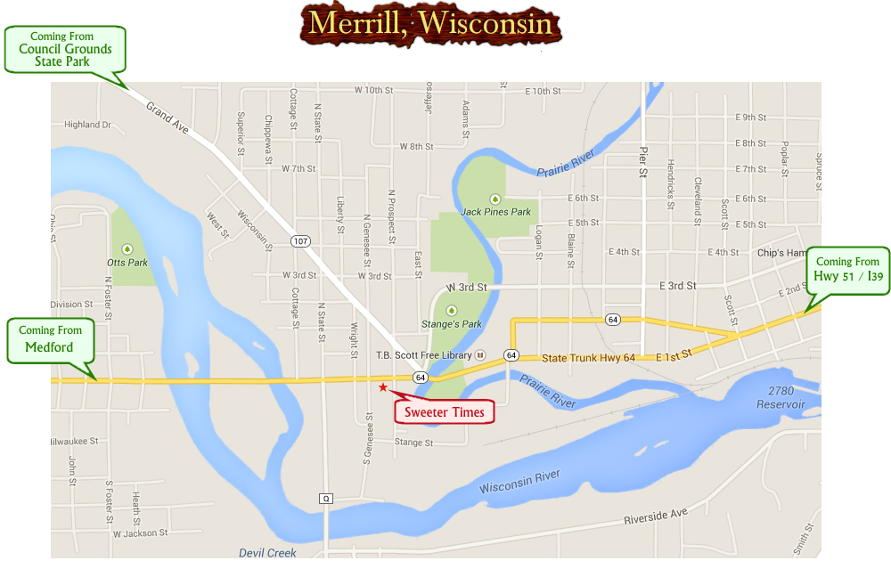
Take the Hwy 64 exit into Merrill. Follow Hwy 64 (Main Street) through town past the town hall and county buildings to Stange Park. Sweeter Times is on the south side of Main Street just 1-1/2 blocks beyond Stange Park.

From Council Grounds

Take Hwy 107 south into Merrill. Follow Hwy 107 (Grand Avenue) through town to Hwy 64 (Main Street). Turn right on Main Street. Sweeter Times is on the south side of Main Street just 1-1/2 blocks past the intersection of 107 and 64.

From River Bend Trail

If you are hiking or biking on the trail, just turn east when you cross Hwy 64. Sweeter Times is just 4 blocks away on the south side of Main Street.